![]()
by Louise Barry
Autumn, 1972 (Vol.
XXXVIII, No. 3), pages 287 to 294
Transcription & HTML composition by Larry E. & Carolyn L.
Mix
digitized with permission of The Kansas State Historical Society.
NOTE: The numbers in brackets are links to footnotes for this
text.
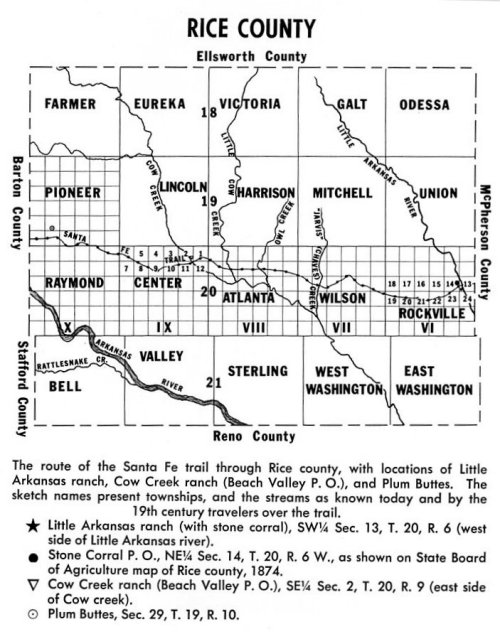
NINETY miles
west of Council Grove, near the eastern boundary of present
Rice county, Santa Fe trail travelers forded the Little
Arkansas river. Joseph C. Brown, the trail's surveyor,
1825-1827, in his report, stated: "It is important that the
ford on the Little Arkansas be found, as it is generally
impassible on account of high banks and unsound bed. The
ford is perhaps half a mile below the mouth of a small creek
[North branch, or North fork], which runs into it on
the east side. At the crossing . . . there is wood for fuel
and the water and grass are tolerably good."
[1] It
appears that William Mathewson (the original "Buffalo Bill")
spent some months in 1857 and 1858 at Little Arkansas
Crossing, trading with the Indians, and hunting buffalo. If
so, no doubt he was the first white "settler" there.
[2]
In February, 1858, the territorial legislature granted E. F.
Gregory and associates the privilege of building a bridge
across the Little Arkansas "where the Santa Fe road crosses
the same." Perhaps Gregory got gold fever later in the year,
for there is no further mention of him. But the "associates"
probably included William D. Wheeler (who soon became the
dominant figure at Little Arkansas ranch), as well as Asahel
Beach and son Abijah (who, in the late fall of 1858,
separated from the group and established themselves at Cow
creek, 18 miles to the west). [3] Augustus
Voorhees, en route to Pike's Peak with the "Lawrence party"
of gold-seekers in 1858, recorded in his diary on June 7:
"Drove twenty-one miles to the Little Arkansas. Saw several
herd of buffalo, one was killed, got but little meat, it was
to far from the road. But little timber on the river and but
little watter. The banks are quite high. They are building a
bridge here. The timber is cotton wood and box elder." The
same day cotraveler William B. Parsons wrote: "Camped on the
Little Arkansas. There is a trading post at this place, and
a bridge in process of erection. The crossing is
abominable." [4] On
July 12 H. B. Möllhausen and party, eastbound, reached
the crossing and "camped on the right bank [west side of
the stream] near a little log cabin which several
adventurers had erected for the purpose of trading with the
Kaw Indians," who were camped "farther above at a distance
of about four miles." Two days earlier, Indian agent Robert
C. Miller, westbound, had arrived at the Little Arkansas,
overtaking there trader William Bent and the wagon train
carrying annuity goods for the Plains tribes. Miller's
subsequent report to the Commissioner of Indian affairs
particularly mentioned the presence of the Kansa "returning
home from the upper Arkansas," who had been in the vicinity
several days, "attracted to the spot by the loadstone of
whiskey, dealt out to them by a creature bearing the face
and form of man, who receives, in return for his vile stuff,
the few ponies and robes they had obtained from the Indians
of the Arkansas." [5] An
unidentified gold-seeker, on his way to Pike's Peak with
some 20 companions, arrived at Little Arkansas Crossing on
October 22, 1858, and camped for a day on the west side. In
his journal he wrote: "This is a fine place . . . We here
once more find the residence of a white man, who hunts,
trades, etc. He is building a bridge across the river."
[6]
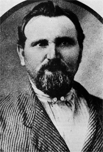
The odds are that William D. Wheeler was the log cabin's
occupant. But no traveler in 1858 mentioned a
name. A
November issue of the Western Journal of Commerce,
Kansas City, Mo., contained a "Table of Distances from
Kansas City to the Gold Regions of Pike's Peak." For "Little
Arkansas," 212 miles from Kansas City, the "Remarks" column
read: "Mail station, store, water, grass, bridge and
Buffalo." About this time, but not known to the
table-of-distances compiler, Asahel and Abijah Beach and
others were establishing themselves at Cow Creek Crossing
(Beach Valley), 18 miles west of the Little Arkansas. It was
at Beach Valley that a post office subsequently was
established, early in 1859. So the mail station at the
Little Arkansas was short-lived. [7]
The
territorial legislature in February, 1859, authorized
William T. Williamson, Columbus Hornsby, Thomas Lounds, and
James C. Horton to "establish a bridge across Little
Arkansas river where Santa Fe road crosses it." There is no
evidence these men made use of their charter, though they
may have operated a ferry, briefly. When William W.
Salisbury, on his way to the gold fields, arrived at the
"little Arcasas" at 11 o'clock on May 18, 1859, he recorded
in his journal: ". . . toll bridge here 25 cts. toll. but
little timber Poore water saw a man that had been shot
acidentely in the hip." Another gold-seeker, Charles C.
Post, crossing there late in May, wrote in his diary: "The
bridge was built last season by Gains & Wheeler, the
owners of it and the ranch, twenty-five cent toll and ten
gallons of water or twenty-five cents for ten gallons and
cross at ferry." These travelers used the ferry and filled
their water kegs "at a spring above one-fourth mile." Post
made an examination of the stone used in the bridge piers.
"It is a kind of lime granite very heavy," he wrote.
[8]
(At a later time J. W. Bean recollected: "The bridge across
the river had been washed away before my day but the piers
were standing five or six feet high. . . ." And George
Hoffman remembered that there were three stone piers, and a
solidly constructed flooring of logs and lumber.) For
1860 little is to be found concerning Little Arkansas
Crossing. A list of "Arrivals at the Gilkey House," Council
Grove, for the week ending August 23, included the name "Wm.
Wade, Little Arkansas." Presumably he was employed at
Wheeler's ranch. In the November 6, 1860, election, held at
Beach Valley, Peketon county voters -- 12 in number --
unanimously elected W. D. Wheeler to the office of probate
judge. [9] A.
I. Baker, Council Grove Press editor, in his March
16, 1861, issue noted that Dr. A. I. Beach, of Beach Valley
(Cow Creek Crossing) and William Wheeler of the Little
Arkansas had "been in town for several days," and commented:
"These gentlemen are pioneers in the true sense of the word;
living far out upon the Western frontier. . . . The March
23d issue of the Press contained this
advertisement: In
the Council Grove Press of May 26, 1861, editor A. I.
Baker wrote: "Our esteemed friend Wm. Wheeler of Wheeler's
Ranche, Little Arkansas, reports all quiet on the plains.
This Ranche is about 100 [i. e., 90] miles
west of Council Grove. The proprietor keeps always on hand,
ponies, horses, cattle, mules, & other live stock to
sell; besides the weary traveler can be entertained to
heart's content. Mr. Wheeler has erected a splendid
toll-bridge across the Little Arkansas at that
place." There
is an information-gap from mid-1861 to mid-1863. (During
this interval the Council Grove newspaper was suspended.) In
his July 6, 1863, issue the Press editor wrote: "We
learn that W. D. Wheeler and all his hands at Little
Arkansas where he has a Ranche and store have been very
sick. Supposed to be poison thrown into his
well." Colorado
troops had a fight with Southern Cheyennes on May 16, 1864,
near Big creek, on the Smoky Hill river (present Ellis
county). Next day, small bands of Cheyennes made retaliatory
stock-stealing forays on the stage stations and trading
posts in central Kansas. (One stage-line employee was killed
on upper Cow creek.) The Council Grove Press of May
28, 1864, noted that the frontiersmen not yet scared out by
Indians included "Wheeler at Little Arkansas." William
Wheeler made no claim for losses on May 17, as did other
area ranchers. It would appear his place was not attacked,
or that he successfully defended his stock.
[11] In
July, 1864, Kiowas, Comanches, and Arapahoes joined the
Cheyennes in depredations along the Santa Fe trail. On the
17th, at Fort Larned, the stock was run off by Kiowas. just
west of Camp Dunlap (Fort Zarah), on the 18th, Kiowas and
Arapahoes killed 10 men of the Crow and Barret freighting
outfits, and scalped two others (who survived). As word of
trouble ahead reached other westbound trains, freighters
corralled their wagons at strategic locations and prepared
to fight or withstand siege. [12] G.
W. Ridge wrote a letter dated "Little Arkansas River, Kan.,
[Sunday] July 24, 1864," which stated, in part: "On
Wednesday last [the 20th] they [the Indians]
came upon three young men (herding) here, killing one and
wounding the other two. They killed 30 head of cattle and
then left. . . . Every train from here to Fort Larned are in
camp afraid to move. There are several hundred wagons camped
here prepared for battle; we expect the fiends hourly. . .
." [13]
(The wounded men, of whom there is no other information,
perhaps were attacked in the vicinity of Little Arkansas
Crossing, but the body of the youth killed on June 20 --
Edgar Miller, of Marion -- was found near present Canton, in
McPherson county.) As
it turned out, the Kiowas, Comanches, and Arapahoes
concentrated their attack on Cow Creek ranch, 18 miles to
the west, and besieged wagon trains corralled in that
vicinity. When Peter Kelly, Santa Fe mail conductor, arrived
at Kansas City, Mo., on July 28, his account of events out
in central Kansas included comment that "At Wheeler's Ranch
some forty head of cattle were lost." It may be that all the
30 or 40 head of cattle lost at, or in the area of, Little
Arkansas Crossing (Stone Corral) belonged to freighters.
Wheeler himself made no claim against the Indians. There is
also the possibility that he had sold out in midyear, or
simply packed up and departed before the July troubles. No
mention of William Wheeler later than May, 1864, has been
found. How many years his toll bridge continued in use is
another question that remains unanswered. No contemporary
reference to it later than May, 1861, has been located.
However, years later a Rice county pioneer -- George
Hoffman, of Little River -- recollected that the bridge toll
was 75 cents when he traveled the trail in the late 1860's.
He remembered seeing soldiers in tents and small huts at the
crossing. [14] And
who was keeping the Little Arkansas stage station in April,
1865, when unidentified Indians stole stage stock from Cow
Creek ranch (on the 24th) and put the stock at Little
Arkansas ranch in jeopardy? Bvt. Brig. Gen. James H. Ford
(then at Fort Zarah) dispatched a company of troops to each
place. "Station Little Arkansas, Kansas" was established,
before April 29, by Cpt. Theodore Conkey and Company G,
Third Wisconsin cavalry. On May 8 Cpt. Carter Berkeley, 2d
U. S. volunteer infantry, relieved Conkey (who went to Fort
Larned). On May 21 Berkeley's Company K, 2d U. S. volunteer
infantry, relieved the Wisconsin troops. Reinforcements from
the 13th Missouri cavalry arrived in June -- Company B on
the 19th; Company D on the 20th; and Cpt. Joel H. Shelly, of
the 13th Missouri, took command at "Station Little
Arkansas." [15] On
the last day in June, 1865, Indians killed, scalped, and
otherwise mutilated three of Captain Shelly's cavalrymen,
and a corporal of the Second Colorado cavalry, in two
separate attacks in the vicinity of Little Arkansas
Crossing. Maj. John E. Mayo (at Cow creek) reported to Maj.
James M. Turley (at Fort Zarah): One
of the victims was dispatch-carrier Cpl. (James?) Douglass,
of Company D, Second Colorado cavalry. The three murdered
13th Missouri men were: Pvt. H. Hogan, Pvt. James Jones, and
(Pvt?) G. W. Norris, all of whom were buried at Little
Arkansas Crossing (Stone Corral); and at a later time
reinterred at Fort Leavenworth. The Junction City
Union's account states that men of Alex. Thompson's
train, on July 1, 18 miles east of Cow creek, picked up the
bodies of five soldiers killed on June 30th while carrying
dispatches. (Another account also says five men were
killed.) But the military report must be assumed correct
both as to location, and number of Victims.
[17] No
further information is available on "Station Little
Arkansas." It appears the troops were withdrawn in July.
Peace talks with the Comanches, Kiowas, Arapahoes, and
Plains Apaches, held at the mouth of the Little Arkansas in
August, 1865, resulted in a preliminary agreement on the
15th to cease hostilities. Peace treaties with these Plains
tribes, and Cheyennes, were made in mid-October, 1865, after
treaty councils held in the same area. From then, till the
middle of 1867, Indian depredations on the Santa Fe trail
were few in number. "H.
J. [i. e., A. J.] Greenway" wrote a letter
dated "Little Arkansas Ranch, May 28, 1867," which the
Junction City Union of June 8, published. It
concerned six soldiers from Custer's (Fort Hays) command
"scouting on Cow Creek, (or rather running buffalo). . . ."
About May 25 these soldiers (deserters, in fact) had
"encountered twenty odd Kiowas and Cheyennes," who, in a
running fight, had killed all but one of them. The survivor,
with "scalp cut around, but not taken," had been brought to
the Little Arkansas ranch by an eastbound wagon train. There
is some reason to suppose that A. J. Greenway may have been
at Little Arkansas Crossing since 1864 (or earlier). If not
there, he was in the vicinity, for he filed a claim of
$1,050 against the Kiowas who had taken seven horses from
him in a July 22, 1864, raid. [18] During
the summer of 1867 soldiers again were stationed at Little
Arkansas Crossing. Cpt. Edward Byrne and Company C, 10th U.
S. cavalry established Camp Grierson there, probably in
June; and remained till November 10. They had no problem
with Indians. But during the months of July and August there
were 17 cases of cholera, and eight deaths, among these
black troops. [19] Theodore
Sternberg -- as recollected by his brother C. H. Sternberg,
in 1928 -- took over the ranch at Little Arkansas Crossing
in 1867. The Sternberg family lived in Ellsworth county,
where another son, George M., was Fort Harker's medical
officer. Theodore (as C. H. recalled) rented a team and
buggy from an Ellsworth livery stable and went down to visit
the ranch. On the journey homeward he happened to look back
and discovered six Indians in pursuit. To outdistance them
he cut the harness, and rode one horse bareback, reaching
home safely, but worn out and sore. Later he returned to get
the buggy, but found the harness had been cut to pieces.
[20] On
July 19, 1870, Z. Jackson, assistant marshal, with an escort
of six soldiers from Fort Harker, took the census in Rice
county. Up in the northeast corner he found five homestead
settlers whom he enumerated as the only residents. Jackson
wrote this note on the census sheet: "Farther south on the
east side of Rice County [at Little Arkansas
Crossing] I found Mr. Theodore Sternberg building a
stone house and had up a large stone corrall for the
protection of his stock from Indians but as it was extremely
dangerous for him to stay here unprotected he spends most of
his time at his father's in family No. 40 in Ellsworth
county where I have him enumerated therefore his name is not
entered as one of the inhabitants of Rice County."
[21] The
stone corrals originally built by William Wheeler in
1859(?), and remodeled by Theodore Sternberg in 1870,
presented a landmark of some prominence to the settlers who
began arriving in Rice county in 1871. One of the later
pioneers -- J. W. Bean -- ,who saw the ranch area about
1880, recollected that the corrals totaled 300 to 400 feet
in length, and about 200 feet in width. The north wall,
still standing then, was "about eight feet high and perhaps
30 inches thick . . . with many stones extending through the
wall, binding it together." There were "one or two openings
about 10 inches up and down, and two feet long on the
inside, tapering to about 10 inches square on the outside"
-- reportedly made in this way so as to get a wide range to
shoot at the Indians. He also recalled that the "walls were
laid perfectly with the slabs fitted so close together that
little or no light showed through," and that a "small room
or enclosure had been fitted into one end. From
December 6, 1872, till August 4, 1880, there was a post
office named Stone Corral. George W. Hodgson, a pioneer of
1871, was the first postmaster. It may be that his residence
was near, but not on, the site. The 1874 State Board of
Agriculture map of Rice county shows Stone Corral P. O. on
the NE 1/4 of Sec. 14, T. 20, R. 6 W. The legal description
of the ranch location is SW 1/4 of Sec. 13, T. 20, R. 6 W.
[22]
Little
Arkansas Ranche The Traveling Public are respectfully
informed, that the undersigned is located on the Little
Arkansas, where the great Santa Fe road crosses the same.
I keep always on hand, Provisions, groceries and Liquors,
also are prepared to accommodate travelers. I have
several large [stone] corrals
[10]
for penning stock, Also, have built a strong and
substantial bridge across the Little Arkansas, for the
accommodation of the traveling public.
W. D. Wheeler Captain
Shelly dispatched me to-day that the Indians have killed
and scalped four more of his command, and captured the
dispatches that you forwarded the other night. The band
of red-skins numbered about twenty-five or thirty and
crossed the Santa Fe road about seven miles east of
Little Arkansas. Killed two of the dispatch bearers.
Passed down and crossed the Little Arkansas about eight
or ten miles below Captain Shelly's camp, where they
found four men of Capt. Shelly's command killing buffalo,
two of whom they killed. I have sent a force to intercept
them, if possible, before they cross the Arkansas river.
[16]
Louise
Barry is a member of the staff of the Kansas State
Historical Society. She is author of many articles on
Kansas and Western history and of the recently published
The Beginning of the West (Topeka, Kansas State
Historical Society, 1972).


