
Ranges West and East from the Sixth Principal Meridian
Ranges numbers extend from 42 West at the Colorado border all the way to 19 East at the Missouri River. A 36-square-mile box in the Range table above could coincide with one of the 36-square-mile boxes in the Town table below.

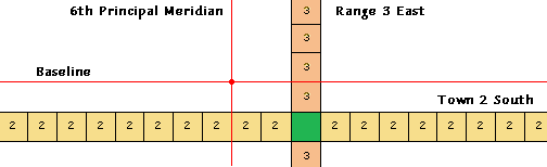
Townships pictured above the Baseline (red horizonal line) are in Nebraska, and those below the Baseline are in Kansas.
The example below illustrates the location of Town 2 South, Range 3 East of the 6th Principal Meridian, which correlates approximately with Washington Township of Washington County, KS.
return to main page Section 22